


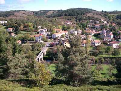
Prévenchères in Lozère


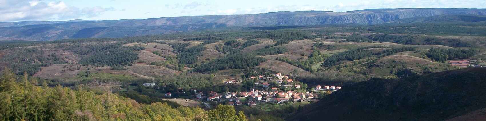
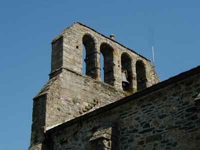
Prévenchères is a picturesque village nestled in the Lozère department, in the Occitanie region, offering a peaceful haven away from urban bustle. Located at the gateway to the Cévennes National Park, it benefits from an exceptional natural environment, ideal for hiking and exploration. Its territory spans part of the upper Chassezac valley, revealing varied landscapes of mountains, chestnut forests, and waterways. The local heritage is characterized by typical schist constructions and its Romanesque church, which testify to its history.
 In the heart of the valleys bathed in light, where periwinkle blooms, lies Prévenchères, a green oasis with Celtic origins. In ancient times, our ancestors saw in the delicate periwinkle healing powers, a touch of magic in its azure petals.
 Prévenchères is a mosaic of landscapes stretching 14 kilometers from north to south and 10 kilometers from east to west. Perched on the edge of Ardèche, at 800 meters altitude, Prévenchères is caressed by a Mediterranean climate, softened by the contours of its majestic mountains.
In the heights of the Cévennes, Prévenchères unfolds its history and tourist charms, inviting travelers to dive into its centuries-old story. The municipality of the village of Prévenchères consists of two picturesque villages, Alzons and La Garde-Guérin (a gem listed among the most beautiful villages in France), and sixteen hamlets.
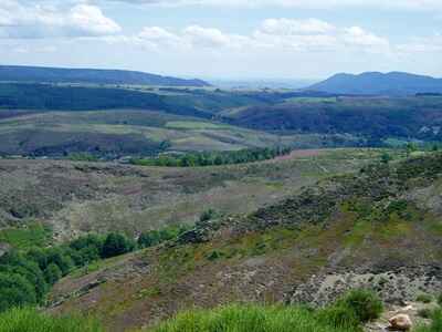
Prévenchères is also distinguished by its undulating hills, ethereal plateaus, and deep gorges, a paradise for hikers and a setting for the Régordane path. This historic route, linking Lower Languedoc to Auvergne, is a pathway paved with stories, possibly dating back to Roman times. The hiking trails passing through Prévenchères include the GR®72, GR®700 Régordane Way, Tour du Chassezac, and Tour de Margeride.
Trade between merchants along the Régordane was a vital aspect of the medieval economy. This historic road served as an important commercial link between the north and south of France, facilitating the trade of goods such as wool, leather, salt, and spices. Prévenchères, located on this route, was a strategic passage for merchants. The region benefited from the economic activity generated by the flow of goods and the cultural interactions that ensued. Merchants used relay points and inns to rest and exchange products, as well as information and ideas.
 The Régordane route was also dotted with fairs and markets where merchants could sell their products and buy necessary goods for the continuation of their journey. These commercial exchanges contributed to the growth of towns and villages along the road, enriching the region both economically and culturally.
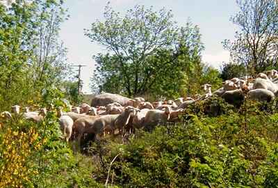 Transhumance, which involves the seasonal movement of herds to more favorable pastures, used paths like the Régordane to traverse mountainous regions such as Margeride and Mount Lozère. These movements were essential not only for agriculture and livestock but also contributed to weaving social and economic ties between different regions.
Since prehistoric times, this natural route has been traversed by wild herds during their seasonal migrations. Over time, it evolved into a route for trade during Roman times and reached its peak in the Middle Ages. It was then the only road connecting Paris to the Mediterranean, used by crusaders and pilgrims heading to the tomb of Saint Gilles or the Black Virgin of Puy-en-Velay. The Régordane was also marked by significant cultural and religious movements, such as Arianism, Catharism, and Protestantism, as well as struggles for freedom of conscience and human rights.
A dense hydrographic network winds through the municipality of Prévenchères, formed by the Altier, Borne, and Chassezac, the latter being the most imposing and capricious. The Chassezac, with its wild and untamed flow, shapes a vital landscape for the municipality, a favored place for hikers and swimmers.
The Gorges du Chassezac are an exceptional natural site located in Ardèche, known for its unique landscapes featuring majestic cliffs, crystalline waters, and abundant vegetation. They stretch for several kilometers, formed by the Chassezac River, which has sculpted its bed over the centuries, creating spectacular rock formations and deep canyons. The history of the Gorges du Chassezac dates back to prehistoric times, with traces of human occupation from that era, such as caves and rock shelters that testify to the lives of the region's early inhabitants.
 Over the centuries, the gorges have witnessed various human occupations, including by the Celts and Romans. In addition to their natural beauty, the Gorges du Chassezac offer a rich architectural heritage with several picturesque villages that have managed to preserve their authentic charm over time. The Gorges du Chassezac are also linked to the history of Neanderthals, particularly at the Fishermen's Shelter, where traces of this human species have been discovered. These findings provide valuable information about the environment and lifestyle of Neanderthals in the area.
 Which region do we associate Prévenchères with? Gévaudan is a province, not a geographical region. About fifteen kilometers north of the municipality, the first remnants of basalt from Velay appear. To the northwest, the Margeride begins at the Montbel plain. To the northeast, the schists soon give way to the gneisses of Tanargue, then to granite: thus we enter Vivarais.
Prévenchères is therefore not in a well-defined natural region. In geography, transitions are never abrupt. Here, the economy is no longer Cévenole. They dance the bourrée. The chestnut trees covering the sunny slopes, and the crumbling schists on the hillsides give the landscape a Cévenol quality. Relations primarily occur with Nîmes rather than with Mende or the Rhône valley. The municipality of Prévenchères is in a borderline area. We might perhaps classify it in the northern Cévennes.
Snow is much less abundant in Prévenchères than in the neighboring municipalities of the plateau, such as Chasseradès. In Prévenchères, train services are sometimes interrupted due to snow (for 5 or 6 days in 1935), but this is quite rare, and the construction of the line did not require special works. In Chasseradès, however, snow tunnels and barriers had to be constructed on the line from La Bastide to Mende, in places where snow frequently accumulated. In this regard, Prévenchères is intermediate between the Cévennes and the plateau. To the north of the municipality, along the old Roman road, these standing stones, about two meters high, first appear, indicating to travelers the course of their path. These stones, resembling milestone markers, are numerous on the plateau roads in places where snow accumulates (every 200 meters on the road from Belvezet to Montbel).
Copyright©etoile.fr