


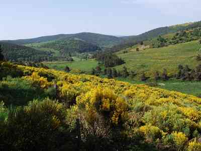
The summit of the Moure de la Gardille, reaching an elevation of 1,503 meters, is located just west of La Bastide-Puylaurent. It is a true paradise for hikers, hunters, and foragers of all backgrounds—a vast, serene no man's land encompassing the 10,000 hectares of the immense forest that formerly belonged to the Abbey of Mercoire. Here, the rolling reliefs are gentle, marked by a long, panoramic ridge traversed by the GR®7. This legendary long-distance trail connects the Vosges to the Pyrenees and ranks among the most famous in France.

From the summit, the view is absolutely spectacular. To the north and east, one can clearly distinguish the Mézenc, the Haute Ardèche, and the sparkling Charpal lake. To the south, two parallel mountain chains stretch as far as the eye can see: the Goulet in the foreground and, in the background, the rugged ridges of Mont Lozère firmly blocking the horizon. We are perched on the very roof of France, not far from the sources of the Allier, which flows towards the Loire, and the Chassezac, which eventually joins the Rhône. On the sweeping slopes of the Goulet massif lie the sources of the Lot, destined to journey onward to the Garonne. The climb is well worth the effort for this panorama alone (provided the weather is clear!).
But today, our goal is somewhat different: we are seeking the elusive source of the Allier. We want to discover this very first trickle of water and drink directly from it, much like one quenches their thirst at the source of the Loire in the clear waters of a "bachat" at Mont Gerbier de Jonc. Three hundred meters higher, we reach the ridge path, which guides us steadily toward the summit of the Moure de la Gardille. The beauty of the landscape is breathtaking; along the way, we happily encounter about thirty fellow hikers accompanied by three sturdy pack donkeys.
At the foot of the Moure, right at a fork, we spot a modest, hand-carved pine sign indicating that the source lies 150 meters "off the beaten track," cascading down the Chasseradès slope. We continue carefully on foot, as from the very first slope, the mountain narrows into a steep ravine, plunging dramatically beneath the dark, protective vault of an ancient beech forest.
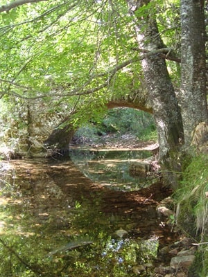
Stepping lightly on a thick carpet of dead leaves and keeping our eyes peeled, we suddenly spot a tiny trickle of water flowing gently into a small, quiet pond. The sun dances on the water, making its reflections sparkle vividly through the leaves fluttering in the wind. The sight is genuinely striking: here lies the Allier, freshly born. But is this truly the exact source we are looking for? According to our guidebook, a pretty enameled plaque should be here, proudly commemorating the adventure of three young people from Langeac who, in 1992, bravely walked up the entire length of the Allier from their hometown to its source over twelve days.
Whether discussing the mighty Loire, the Nile, or the Mekong, there have always been passionate controversies regarding their exact sources. We would have loved to avoid this kind of historical confusion, but alas, there is no trace of the commemorative plaque here. However, painted on the thick trunk of an old beech tree in the familiar yellow of trail markers, an inscription reads "ALLIR," complete with a missing or peculiar final "R." Is it a simple spelling mistake or local patois? It remains a charming mystery. A kilometer further down the trail, we finally arrive at a small cement dam, officially inaugurated in 1995 by the mayor of Chasseradès: this is the very first development on the Allier river. And indeed, the famous plaque is located right there.

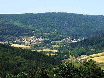
The day concludes on a wonderfully positive note, especially since we decide to extend it in excellent company. Resting on a sunny terrace, we meet two female hikers traveling the iconic Stevenson Trail (GR®70) from Le Monastier-sur-Gazeille to Saint-Jean-du-Gard. They speak enthusiastically about L'Etoile, a lovely guesthouse located in La Bastide-Puylaurent.
The owner of the establishment clearly left a strong impression on them: half-Greek, half-Belgian, a passionate musician, and a tireless adventurer in his spare time—a true, unforgettable character. Philippe Papadimitriou is a modern-day cowboy who proudly boasts, with a twinkle in his eye, that he has only read five books in his entire life. A pragmatic, "hands-on" man, he could undoubtedly provide us with the definitive story about the river's source.
We naturally decide to stop by his place on our way back. The towering innkeeper welcomes us, his large, clear eyes wide with surprise: "The source of the Allier? Do I know it? No. But honestly, what does it matter?" He is right; the Greek makes a brilliant point. The quiet trickle of water hidden under the beeches is quite enough magic for us. The "official" source, the "true" one? It simply doesn't matter. The sun is shining brightly, the Lozère is magnificently beautiful, and life is undeniably good.
***
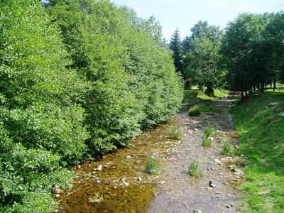
The great watershed line between the Cévennes and the Margeride decisively crosses this territory, which is uniquely positioned between two major drainage basins: the Rhône-Mediterranean basin and the massive Loire-Brittany basin. As a result, the hydrographic network of the municipality is incredibly dense, laced with numerous streams and "valats" (a traditional Cévennes term for a narrow, steep stream), such as the Rieufrais stream or the Gouttes. On the side of the Loire-Brittany basin, the young Allier winds its way into the spectacular gorges of the same name before eventually joining the mighty Loire. Meanwhile, the southern tributaries flow rapidly towards the Chassezac, ending their long journey in the Ardèche, deep within the Rhône-Mediterranean basin. This remarkable water abundance allowed for the construction of the impressive Puylaurent dam, though it also represents a significant natural hazard. The territory is regularly subjected to torrential rains—sometimes violent "Cévenol episodes"—which can trigger sudden floods. Finally, let us always remember that it is just west of La Bastide, near the Moure de la Gardille, within the former commune of Chasseradès, that the Allier takes its source. It is precisely here that the very first trickle of this 420-kilometer-long river is born.
Coypus and elusive beavers are among the fascinating species that can be quietly observed along the banks of the Allier, a river famously rich in biodiversity. Its fish population is particularly varied and vibrant, including prized species such as trout, grayling, and pike. However, the construction of numerous massive dams along the Loire sadly led to the near-disappearance of the legendary Allier salmon (Salmo salar). Several critical factors are responsible for this decline: the absence or severe inadequacy of fish ladders, significantly reduced water flow, the rapid siltation of vital spawning grounds, dangerously decreased dissolved oxygen levels, steadily increasing average water temperatures, as well as rampant poaching. Fortunately, passionate volunteer efforts have been tirelessly deployed for years, striving to successfully reintroduce this mythical fish, which remains the proud origin of a millennia-old cultural tradition in the region.
Since the late 1990s, dedicated restoration efforts have been vigorously implemented to safely encourage the return of salmon to the Allier. These ambitious initiatives include the establishment of specialized developments designed to facilitate their upstream passage, extensive habitat restoration, and the careful, sustainable management of the surrounding aquatic ecosystems. Strategic repopulation programs have also been carried out to actively increase the fragile salmon population. These sustained efforts are slowly bearing fruit, and there have been highly encouraging reports of salmon swimming upstream in recent years. However, the situation remains delicate, and the strict preservation of their natural habitat and water quality within the Allier is absolutely crucial to ensuring the long-term survival of this emblematic, fighting species.
The majestic Allier salmon holds the incredible distinction of undertaking the longest migration in all of Western Europe. In 2018, exactly 389 salmon successfully crossed the Vichy passage, while the average over the previous five years stood at 677. To truly ensure the long-term viability of the species in the river, experts estimate that a minimum of 2,000 adult passages are needed each year during spawning. Over the past twenty years, hopeful record ascents were logged in 2003 and 2015, with approximately 1,200 resilient salmon making the journey. According to the dedicated Allier Salmon Protection Association, the main formidable barriers to this epic migration remain the Poutès dam in Haute-Loire (despite recent developments), the imposing threshold of the Lorrains in the Nièvre (originally built to supply the lateral canal to the Loire), as well as the heavy presence of natural predators such as catfish and cormorants, a large colony of which has firmly established itself just downstream of Vichy.
The GR®470, famously known as the Trail of the Gorges of the Allier, is a magnificent long-distance hiking path. It faithfully follows the Allier river from Brioude in the Haute-Loire all the way up to its source at the Moure de la Gardille. This awe-inspiring route of about 200 kilometers crosses wildly varied landscapes, plunging into impressive gorges, navigating dense ancient forests, and passing through a multitude of charming, historic villages.