


Les Vans in Ardèche


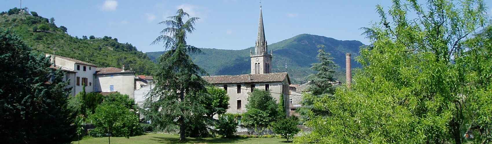
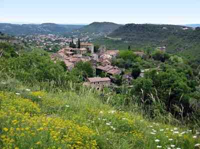
 Les Vans is a commune located in the Ardèche department in the Auvergne-Rhône-Alpes region, at the heart of a basin near the Chassezac river. It is part of the Monts d'Ardèche Regional Nature Park and the peripheral zone of the Cévennes National Park. Its climate is Mediterranean, with hot, dry summers and mild, humid winters.
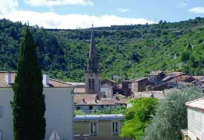 The first traces of human presence in the Les Vans region date back to prehistoric times, as evidenced by numerous decorated caves and dolmens. Later, the Gallo-Roman era also left its mark with the Roman road that crosses the territory. Les Vans only appeared as a town in the 12th century, under the influence of the Abbey of Saint-Gilles-du-Gard, which owned the Church of Saint-Pierre-aux-Liens and its borough. The town developed due to trade and craftsmanship, particularly leatherwork and the production of wineskins. It was surrounded by a fortified wall pierced by four gates, protecting it from attacks.
In the 16th century, Les Vans was affected by the Wars of Religion and embraced the Reformation. The church was destroyed and rebuilt in the 17th century in a Baroque style, featuring a magnificent altarpiece offered by Claude de Roure, abbot of Malons. The town then experienced a period of prosperity thanks to silk and mulberry cultivation.
In the 18th century, Les Vans became the chief town of a canton and hosted several notable figures, such as the Marquis de Mirabeau, the father of the famous orator of the French Revolution, and the naturalist Olivier de Serres, who resided at Le Pradel. The town actively participated in the Revolution and saw the birth of local figures such as General Dugas-Montbel and Deputy Jean-Baptiste de Borne.
In the 19th century, Les Vans experienced demographic and economic growth driven by agriculture, industry, and commerce. The town modernized with the construction of the town hall, courthouse, theater, washhouse, hospital, and several schools. It also benefited from the arrival of the railway, connecting it to Alès and Aubenas. (Note: Les Vans switched to the Reformation in the 16th century, followed by a return to Catholicism and the dismantling of its fortifications in 1629. Two annual fairs were granted by Charles VII in 1453. The municipalities of Brahic, Chassagnes, and Naves were united and associated with Les Vans in 1973).
 Located in the Cévennes National Park, Les Vans offers diverse landscapes, including mountains, plateaus, and rivers. Hikers will find many trails, including the GR®4, GR®44, and GRP Le Cévenol, which traverse the commune.
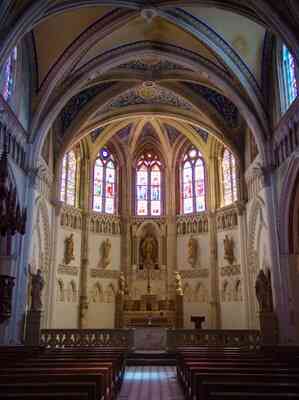
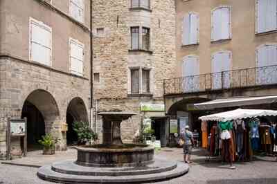
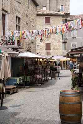
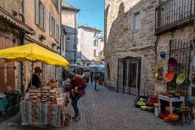
 Points of interest include the Church of Saint-Pierre, built in the 17th century, and the Chapel of Sainte-Philomène, dating from the 19th century. The commune also has several museums, including the Ardèche Heritage Museum, which traces the history and traditions of the region. Finally, the weekly market in Les Vans is renowned throughout the area for its friendly atmosphere and the quality of its local products, particularly seasonal fruits and vegetables, cheeses, and Ardèche wines.
The town of Les Vans occupies the center of a basin watered by the Chassezac river. It is dominated to the southwest by the jagged ridge of Serre de Barre, the last eastern peak of the Cévennes in lower Vivarais. Les Vans is a pleasant holiday destination and a starting point for many excursions into the Cévenol Vivarais and the Chassezac valley. The most spectacular routes lead to the village of Thines (15 km north via the D901, D13, and D513), perched above a stream and featuring a church built from differently colored sandstone, and to St Jean de Pourcharesse (18 km north via the D10), from where the view of the "beaks" of the Banelle and Guidon du Bouquet is breathtaking. One can also use the D113 to ascend the very narrow Borne valley up to Beaumes.
The Païolive Wood (Bois de Païolive). This limestone chaos extends over just over 15 square kilometers on both banks of the Chassezac. It consists of enormous rock blocks with strange shapes, some resembling fantastic animals. By taking a path that branches off from the D252 coming from Les Vans, one arrives at the Chassezac cornice in twenty minutes. The emerald green river flows between 150-meter-high, completely vertical white cliffs, pierced with numerous caves.
***
The Land of Les Vans
Once upon a time, there were modest heroes here, clearing a patch of land slightly less stony than the rest, or guiding flocks along uncertain paths southward towards their winter pastures, or northward towards the great meadows of July. There were also all sorts of outcasts, from salt smugglers of the Old Regime to the Chouans of Vivarais, who were as valiant as those from elsewhere—forgotten fighters of a murky cause, of a monarchy and a Church finally welcoming all the poor wretches of the earth. Not to mention, of course, the highwaymen.
 From one end to the other, these two lands—perhaps a third runs through them like a sword stroke—are shaped by a river that shivers with its name, called the Chassezac. It comes from higher up, one of the many streams of Mount Lozère. It plunges a little lower into the Ardèche river, acting like a younger sibling to it. In the blue land, which consists of schists and sandstones, it carves a valley deeper than that of an ancient plowman. In the white land, made of limestone, it plunges suddenly, rolling out a long green or black ribbon hundreds of meters beneath the astonished steps of the walker. At the highest of the promontories overlooking the river stands a sentinel between rock and wind: it is the old hermitage of Saint-Eugène, so high, airy, and white that, when observing it, it is hard to tell whether it is a piece of earth rising skyward or a piece of sky illuminating the earth.
 Such a variety of landscapes, and therefore resources, could not leave our distant ancestors indifferent. Traces of them can be found from the Paleolithic along the Chassezac, for example at the Abri des Pêcheurs, which became famous thanks to a team of passionate prehistorians. On the limestone plateaus, dolmens and sepulchral caves abound: fishing, hunting, agriculture, and livestock fed these lands inhabited by people with forgotten names. On the barred spur of Casteljau, traces of a Gallo-Roman villa can be distinguished, as well as the ruins of the medieval castle of Cornillon. Naturally, the road connecting the upper and lower lands was dotted with strongholds.
To the south, on a sandstone ridge overlooking the main road leading to the great Benedictine abbey of Saint-Gilles on one side and to the Marian city of Le Puy-en-Velay on the other, stood the castle of Banne. Unassailable and perhaps a thousand years old, it burned during the great Revolution, just like the nearby Commanderie de Jalès, from which the Templars, followed by the Hospitallers of Saint John, reigned for half a millennium over a population of peasants supplying wheat, chestnuts, and convers.
A little further north, it was necessary to cross the Chassezac: this was the work of the monks of Saint-Gilles as early as the 12th century, and they settled on either side of their bridge in the priories of Chambonas and Les Vans.
 Three castles additionally overlooked the passage: that of Chambonas, long entrusted to lords descending from their eagle's nest at La Garde-Guérin, sold after the Revolution to the Chanaleilles who considerably modified its appearance; that of Navel, whose lord, as of 1274, was King of France Philip the Bold; and finally that of Chassagnes, which belonged to the powerful Montjeu Family.
Naturally, the monks were great builders of churches: that of Les Vans was lost in the tumult of the Wars of Religion; rebuilt in the 17th century, it is especially known for its magnificent Baroque altarpiece, a work by the Brabançon painter Jean Engelbert created in 1682, and for its choir stalls originating from the destroyed abbey of Chambons, higher up in the Cévennes. However, one can still admire the beautiful Romanesque church of Chambonas, that of Navel, or even that of Gravières with its stone altarpiece representing the tree of Jesse. At over 400 meters in altitude, the church of Saint-Jean-de-Pourcharesse, with its slate roof, machicolations, and old Romanesque porch, still watches over the draille (drovers' road) that led from Joyeuse to the Peyre inn, where it met the steep path from Les Vans.
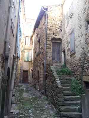
 The main road slightly diverted to the west into a kind of inlet surrounded by Cévennes' ruggedness: the small town of Les Vans, which offered, in this scorched land where the slopes were steep, a bit of space and water. Leatherworkers, wool workers, and sheep herders were present there as early as the 13th century, not to mention those attracted by the surrounding agriculture, from barrel makers to clog-makers.
The town was surrounded by ramparts at the end of the 14th century to protect itself from the Routiers or Tuchins who ravaged the countryside. It was an ecclesiastical lordship, although the royal bailiff held court at the very heart of the city from 1413. Perhaps that is why the Reformation erupted here with such vigor; for centuries, the small Huguenot city resisted pressure from the Catholic countryside while, from the Grand Siècle onward, it also provided silkworm seeds, tools, and usurious loans. This soon allowed it to acquire lands, build spinning mills, and even construct small castles like that of Scipionnet, whose towers mocked the old landowning and Catholic nobility.
 It is no surprise that the Revolution was preceded here by agitation hostile to the bourgeoisie of Les Vans, known as the revolt of the Masks (because wrongdoers would smear their faces). However, during the Revolution, it was a whole different tune; the entire Catholic peasantry gathered armed in the plains of Jalès, in 1790 and 1791, to defend the King and the Faith. Full of hope, the émigré princes fomented a revolt called the "conspiracy of Saillans," which ended with the burning of the castle of Banne and the massacre on July 14, 1792, in the Place de la Grave in Les Vans, of priests who had unfortunately taken refuge in the area.
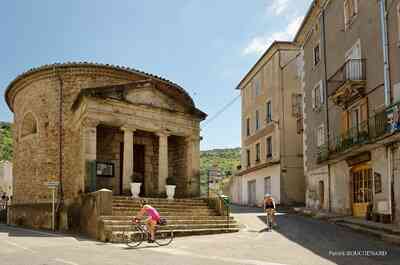
The socio-religious conflict only faded very slowly in the 19th century, with the departure of prominent Protestant families to more tolerant and rewarding skies, and the incessant arrival of mountain dwellers attracted by the spinning mills and weavers, as was the case throughout the Cévennes. The temple, built in 1824 on the road to Saint-Paul-le-Jeune as a modest rotunda with a peristyle, still looks quite grand.
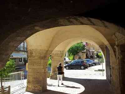
 The century of industry left more memories than physical traces. Coal was long extracted at Pigère, at the northern tip of the Alès vein. The Bourdaric, the modest brook of Les Vans, was covered over and still flows beneath the Place de la Grave. The great man of the century in Les Vans was the surgeon Léopold Ollier (1830-1900), whose statue once overlooked a modest tram that connected Les Vans to Aubenas and Saint-Paul-le-Jeune. The murmuring fountain on the Market square, which remains the heart of the city, also dates back to that time.
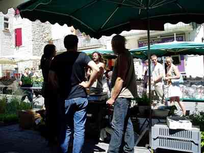
On Saturday morning, market day, the two countries meet in the streets and squares of Les Vans. Long-haired and bearded neo-hippies still come down from the Cévennes to offer their cheeses; olive growers come from Cruzières or elsewhere to sell their oil, which competes with that of Nyons for quality. Winemakers offer a little glass of Merlot, Viognier, or Syrah, and these wines from Vivarais, recently promoted to the rank of controlled designation of origin, are worth as much as any others. And then there is the crowd of onlookers, who come to buy a salad and two onions, or to buy nothing at all—simply to savor the scents, listen to the hum of the crowd, and taste the sun. The land of Les Vans. By Michel Rissoan. Published by La Fontaine de Siloë.
 The small hamlet of Mognard (on the road from Villefort, about 8 km from Les Vans)
"Before 1914, there were 7 inhabited houses, making 13 adults and 14 children in Mognard. The school of Mas de la Font, located 500 m away, was built in 1912. The teacher had us knit socks for the soldiers. Some women wore white or black bonnets; we wore 'braillettes' (panties of the time) with lace and ribbons. For wool, we had a distaff and a spinning wheel. Water was not available in the houses, but my father (always ahead of his time) had captured a spring (located several hundred meters away) to supply the washing basin he built in 1898. He soldered the pipes with tin spoons… the service was there!
We lit our homes with kerosene lamps, pigeon lamps (gasoline), 'lum' oil lamps, or candle lanterns. The fireplace served both for cooking and heating the main room, as well as for warming the stones for the beds. Laundry was done once a month in a large tub with vine shoot ashes... we washed ourselves in the horse's yard. Each family had 3 or 4 goats and 50 sheep in Mognard. We had one cow for the winter, which we would slaughter in the spring with the neighbors, one pig per family raised over a year, chickens, rabbits, and a half-share horse with the neighbor. In every family, they raised silkworms; one girl worked in the spinning mill of Les Vans. Wine was made in each house. My father would sell it by cart as far as Bleymard in Lozère (50 km away); he would leave before dawn and return at night... tired, he would fall asleep on his cart... but the mare Mira knew the way..." Statements collected from a grandmother born in Mognard in 1903.
Copyright©etoile.fr